
Riding “The Old West Scenic Bikeway”
Last summer, when we did our Big Adventure Small Wheels tour, we rode from Bend, OR to Glacier National Park. Our favorite part of that entire stretch was riding through Eastern Oregon. We loved rolling through all the small towns, like Mitchell, Prairie City and Halfway. As we pedaled along, we made a mental note that we HAD to come back to this part of the state to explore more. We recently got a chance to ride the newly designated Old West Scenic Bikeway for an upcoming magazine article and jumped on the opportunity. When we rode last summer, it was primarily on the Adventure Cycling Association’s TransAm route. The Old West Scenic Bikeway runs along the TransAm from Dayville to Austin Junction, but then turns into relatively undiscovered and amazing bike touring country.

The Brass Tacks
The Old West Scenic Bikeway is part of the relatively new Oregon Scenic Bikeway program. The idea is to create a signed route on pre-existing roads that showcases Oregon’s stunning scenery, road riding and small communities. It is a fairly rigorous process for a route to be designated, and proponents (including Oregon State Parks, Travel Oregon, Cycle Oregon and others) ride the routes beforehand to ensure their quality. While some potential routes are denied, this is ultimately a good thing since you can be guaranteed an amazing cycling experience.
The Old West Scenic Bikeway is a 174 mile loop with a suggested start in John Day. While you can really start anywhere along the route, John Day is a good place since there are lots of accommodations and services. If you drive out there, you can leave your car at the Kam Wah Chung Visitor’s center (just let them know first).
At only 174 miles, the route has various potential itineraries, from a sporty 2-3 day tour to a leisurely 4-5 day tour. We chose a truly leisurely pace, with lots of time for photos, so we rode the loop in 5 days.
Probably the biggest concern to keep in mind is the lack of facilities between Austin Junction and Long Creek, as well as between Monument and the John Day Fossil Bed’s visitor’s center. These are long stretches with no food or potable water (there is a river but it is advised you filter/purify it). We did this loop in the spring so the temperatures were low (a little too low actually!) and we didn’t sweat too much from the heat. In the middle of summer, carrying enough water will definitely be a challenge.
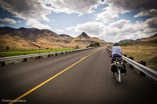
Day 1 – John Day to Austin Junction (30 Miles)

This was familiar riding to us, having done it last summer. This portion of the OWSB is well traveled by bike tourists, as it’s along the ACA TransAM route. You pass through several small communities where you can grab a good hamburger and beer and visit shops with various curios. The climb up to Austin Junction begins just after you leave Prairie City. While long, the grade is fairly consistent and allows you to get into a good rhythm. After the summit and a lovely descent, Austin Junction Cafe is a real treat. The food is good (they also offer gluten free buns!) and the owners are very hospitable towards bike tourists. We spent a few hours in the bar, warming up and enjoying dinner/beers. From Austin Junction, it’s only a mile to the brand new Bates State Park. Bates has hiker/biker sites located under the few large trees in the park (having only opened last fall, the newly-planted trees haven’t grown in yet). The hiker/biker site also has electrical outlets (the first in any hiker/biker site we’ve seen). We bought firewood from the friendly camp host and ended the first day by the fire, watching geese fly over head and enjoying the nearly empty state park.

Day 2 – Bates State Park to Long Creek (53 miles)
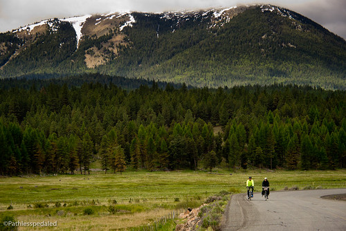
This is where the OWSB diverges from the TransAM route. We thought the first day of riding was pretty good, but this stretch was spectacular! Seriously. You leave the main highway and follow a smaller county road that runs along the North Fork of the John Day River. It was simply stunning country with the river on one side, trees all around us, big rock structures looming overhead and snow-capped mountains in the distance. It was one of those roads where the next turn always brought on some new and amazing vista. The riding along the river was fairly flat, though we were met with 20mph headwinds which made the distance more challenging than it should have been. After being beat up by winds for the better part of the day, we climbed up from the river valley to Long Creek, a fairly significant climb at the end of the day, with some steep rollers into town. By the time we got into Long Creek, I was ready to eat the tire off my bike. Fortunately, the market/feedstore/cafe was still open and I ate a double burger with bacon and a rootbeer float instead. We stayed at the only motel in town (which has wifi!) and collapsed into bed.

Day 3 – Long Creek to Big Bend BLM (32 miles)

We begrudgingly got out of our warm soft beds the next morning and had breakfast at the cafe (special ordered homestyle potatoes with cheese and bacon). The landscape around Long Creek was completely different from the day before. There were fewer trees, more grasses and larger vistas. The riding was leisurely since we knew we didn’t have to do big miles. For the most part, we were simply ooohing and ahhhhing at the wide-open scenery around us. At some point we hit the highest point of the route and enjoyed a screaming long downhill into Monument. Again, the landscape constantly amazed and I had to pull over several times to take photos. Monument is a tiny blip of a town that has a surprisingly well-stocked market that makes a perfect place to restock.

From Monument it was another 12 or so miles to a couple of BLM campsites. We stopped at the first one we found, Big Bend. It’s an incredibly primitive campground, with just a simple vault toilet and no potable water. But what it lacked in facilities, it made up in scenery. Our site was about 20 feet from the river’s edge. I took out the fly rod and cast to some rising but stubborn fish. No luck. That evening we enjoyed another campfire (the folks next to us generously offered us some wood) and we enjoyed the beers we picked up from Monument.

Days 4/5 – Big Bend to Dayville (30 miles) / Dayville to John Day (31 miles)
We could have ridden this stretch in one day, but when the scenery is this good, what’s the rush? We left the BLM site bright and early and continued through the rocky landscape. The riding was quiet and undulating.

It’s hard to not use too many superlatives when talking about this route, but again the riding was amazing. I thought we had seen the best this route had to offer, but passing by the majestic Cathedral Rock and through Picture Gorge kept surpassing our expectations. We stopped at the visitors’ center at the Fossil Beds (the first place for potable water after Monument) and took a long break. From there it was an easy ride through Picture Gorge and into Dayville.

In Dayville, we stayed at The Fish House Inn, in a small and country-furnished room. The Fish House also allows camping. Or you can stay in the community room at the Dayville Pesbyterian Church, which has showers, a kitchen and even a computer room with WiFi!

From Dayville, it is a fast and straight shot back to John Day. While there was slightly more traffic, the road generally had wide shoulders. There were a few undulating hills but no big climbs. The roads out there scream to be ridden with a light road bike! In John Day, we wrapped up our trip with some celebratory hamburgers at Outpost Tavern (also has wifi) and packed up the car and headed back.
Final Thoughts
We’ve ridden a lot of touring miles throughout the US and can honestly say that the Old West Scenic Bikeway was some of the most pleasurable and scenic riding we’ve done! In 174 miles, you pass through a string of small western towns, a quiet river valley lined with pines, grassy ranch land, and colorful rocky terrain. Not to mention there was hardly any traffic! Our trip was over Memorial Day weekend, and the traffic was so light it was almost non-existent.
The only real challenges are being able to carry enough water and getting to the start. As of this writing, there is no easy way to get to John Day via public transit/bus with your bicycle. It is possible but it is expensive and inconvenient. The bus from Portland to Bend requires that you break down your bike for airline travel (#FAIL)! From Bend, there is a bus that will take you to John Day, and we hear that they’re eager to outfit their buses for cyclists. We managed to hitch a series of rides out and back, but would have loved to utilize cyclist-friendly transit.
If you’re an experienced tourist, the OWSB would make a lovely multiday bike vacation. If you want to ride the roads without having to carry camping gear, there are just enough motel options so you can travel light and fast. Hopefully more accommodations and shuttle services will arise as the OWSB becomes more popular. Because of this experience, we are looking forward to riding the rest of the Scenic Bikeways in Oregon. So if you’re visiting the state (or are a bikey Pacific Northwesterner) and are looking for a 3-4 day bike tour through some quiet country roads, check out the OWSB.
A furnished house and cabins are now available halfway between Kimberly and Dayville for cyclists with more than pocket change. Both places include breakfast items and you could probably talk the owners into having dinner supplies for you.
These places, as well as the Bike Inn in Mt Vernon, will soon be on http://www.rideoregonride.com
Thanks for the great article on our great scenic bikeway!
Wow! Terrific photos. Thanks for sharing.