
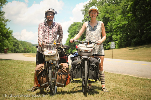
Our Natchez Trace Adventure: Jackson, MS to Nashville, TN
The Natchez Trace has a great history. A one-time Native American foot-path that became a travelers highway and mail route as the US expanded westward, the Natchez Trace eventually fell into disuse with the evolution of river steamboats until it wound up in the hands of the National Park Service and became the parkway that we know now.
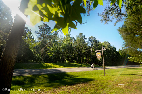
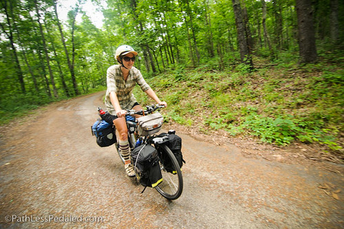
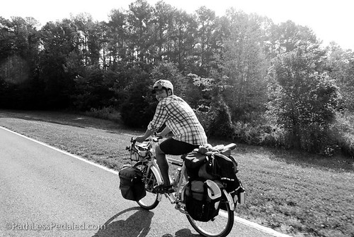
The Natchez Trace is a beautiful road – and, if you haven’t already traveled along it, you should make plans to come visit. Heavily forested on both sides, the Natchez Trace is a two-lane road (one in each direction). There is no shoulder, but the entire parkway has been designated as a bike route, so cars are relatively used to seeing cyclists (and, we found, they’re fairly content to just go around and give you a wide berth). The pavement is smooth almost the entire distance and commercial traffic is banned, so it’s an extremely pleasant riding experience.

In truth, the Natchez Trace isn’t much different from a lot of country roads that we’ve ridden along – quiet, low traffic volumes, helpful and friendly people. But there’s something that makes the Natchez Trace a destination, and it has been great to meet other touring cyclists headed up or down the parkway (although not nearly as many as we had hoped).
Services are fairly frequent, but require some advance thought, as there is nothing right on the Trace and very little that is visible or signed from the parkway. The National Park Service produces a map of the entire parkway, with picnic areas and campsites marked, and mileage markers noted. Separate lists are available online and at each information center (and often the restrooms along the Trace) that tell where camping and services are available off the Trace.
Lodging runs the gamut and is much more plentiful than we imagined. The National Park Service has three designated campgrounds along the Trace. They each have restrooms and water (but no showers), and camping is free. The National Park Service also has five designated bike-only campgrounds along the Trace. For the most part, these are just picnic areas where it has been deemed okay for cyclists to stop and camp (again, for free). All but one (at milepost 408) have restrooms and water within easy walking distance. If you get off the Trace, there are private campgrounds scattered up and down the length of the parkway. Quality of services varies, but they’re a great way to get a shower, and we haven’t paid more than $7 per night per person. And, finally, there are opportunities to stay indoors. Besides WarmShowers hosts, several towns along the Trace have motels or Bed & Breakfasts. Not all of them are listed online, so be sure to ask around.
The entire length of the Natchez Trace is 444 miles, from Natchez, Mississippi to Nashville, Tennessee. We hopped on the Trace just north of Jackson, Mississippi, thus missing the first 100 miles. But we have loved what we have seen and hope that you all will get a chance to experience it as well.
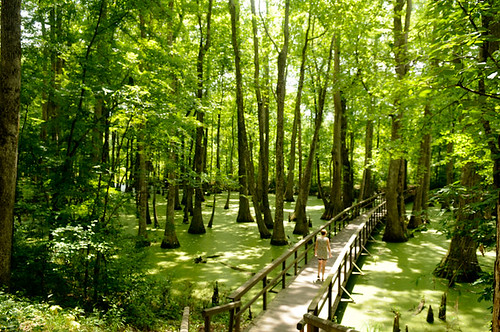
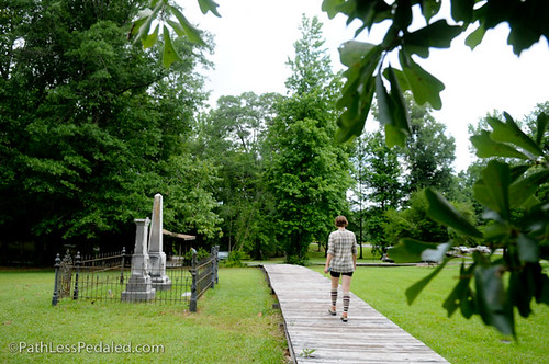
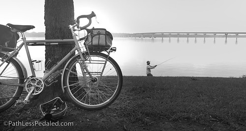
Leaving Jackson, Mississippi, the Natchez Trace parallels the Ross Barnett Reservoir for almost 20 miles, and you get beautiful views across the expansive body of water. You also pass a number of swampy areas, including one with a long wooden walkway that allows you to wander into the middle of the eerie stillness.
That first night, we opted to stay at Ratliff Ferry, a small private campground just a half mile off the Trace. Tent camping is $5 per person per night, and they have a small grassy area with picnic tables and a fire ring, all set apart from the RV section of the campground. Their showers are less-than-stellar, but they have a small store that’s open daily and a bar/restaurant that’s open on the weekends. The campground is located right along the Pearl River, and if you go down to the water’s edge at dusk or later, you’ll see lots of alligators slowly drifting through the river.
From Ratliff Ferry, we continued our north-ward trek. There are lots of historical sites along the Trace, each with a large wooden sign that tells you what’s important about that area. These make for great stops when you’re on a bicycle, because you can pull right up to the sign, read the information, get a swig of water or a snack, and easily be back on the road. Some roadside stops have short nature walks that can also be a great diversion. We stopped at the small picnic area of Holly Hill on that second day and waited out a thunderstorm that had rumbled through. Then, we continued on to Kosciusko, where we had arranged a homestay. The word had reached us of great WarmShowers hosts there in town. And, while Donna and Gary were out of town while we were passing through, they graciously allowed us to stay at their house, connecting us with their housekeeper.
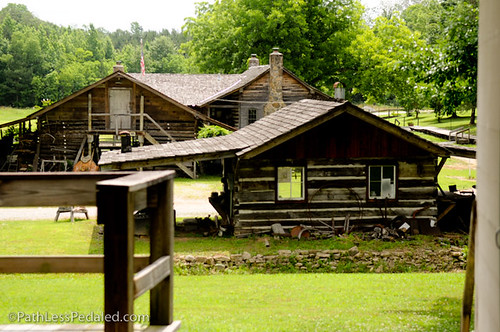
From Kosciusko, it’s a quick 20 miles to the small community of French Camp. Founded back in 1812, French Camp is only a quarter-mile off the Trace. The old buildings have been restored into a gift shop, café and museum, and there is a Bed & Breakfast on site as well. If you go through this area, we highly recommend eating at the café. They menu is small, but their sandwiches are fantastic. They bake their bread fresh every day, and you can buy a bag of their coffee in the gift shop.
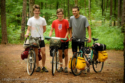
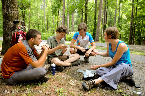
From French Camp, we headed up to Jeff Busby, one of the three National Park Service campgrounds. At one point, Jeff Busby had a gas station with a mini-mart and wifi, but it has all been shut down now. But the campground itself is beautiful. We met up with three kids who had just finished their junior years in high school and who were touring the Natchez Trace before other summer commitments. We spent the afternoon and evening chatting with them and another tourist that rolled in later in the day.
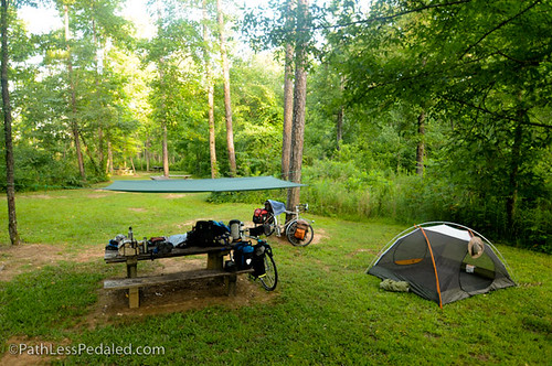
From Jeff Busby, we rode most of the day with the other tourist we had met the night before. We all stopped in the small town of Mathiston to get some food, and discovered (again) that almost everything is closed on Sunday mornings in Mississippi. We had to skip the grocery store and go to the Subway at the gas station instead. That night, we opted to camp at the bike-only campground at Witch Dance. It’s a lush, green picnic area with restrooms and water, and you’re allowed to pitch camp by the tables across from the restrooms. It’s a beautiful spot, but feels a bit like camping at a rest area.
The next morning, we were up early, tired of the heat and humidity. We had decided that we would spend two nights in Tupelo, to rest up and cool off. There is actually a bike-only campground on the Trace outside of Tupelo, behind the visitor center. You can either pitch a tent or roll out your sleeping bag on one of the plywood bunks in an old wooden cabin. We plunked down for a motel room with A/C. Tupelo is a neat little town, with a downtown area that feels like it’s on the verge of a comeback. There’s a great coffeeshop, an artist co-op and a small gallery, along with a farmer’s market three days a week.
From Tupelo, we headed up to Tishomingo State Park. Tishomingo is about a mile off the parkway, and the campsites are set alongside a small lake. The showers are fantastic, even though the bath house looks pretty shabby from the outside. Russ spent the afternoon fishing in the lake, while I set up shop on the picnic table. We set up the tarp over the table and hid under it as a series of thunderstorms passed over us throughout the afternoon. That night, a large and very slow-moving storm rumbled through the area and soaked everything. And a pair of raccoons took advantage of the situation and broke into our M&Ms and tortillas.
In the morning, tired from the storm and chasing raccoons, we got up slowly, tried to dry out some things, and decided to ride a very short day. We crossed the state line into Alabama and headed up to Colbert Ferry, a picnic area and boat launch along the Tennessee River. We met several friendly bike tourists that day, but none were planning to camp where we were. We spent the afternoon down by the river, and wished that we could pitch camp there instead of the designated bike campground, which is hidden in a small circle of trees off the road and away from any of the facilities. Due to the storm the night before and the high humidity, we felt as if we were sleeping in a sauna, and we spent the night listening to the water-logged trees groan and creak and fall down around us. None of them fell on us, thankfully, but we didn’t sleep particularly well, regardless.
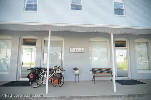
We had planned to get up early the next morning and ride all the way up to Fall Hollow, where we knew we would find a shower. After crossing the Tennessee state line, we stopped in the small town of Collinwood for lunch. Other cyclists that we had met had raved about the buffet lunch at Chad’s, so we had to check it out for ourselves. We stopped first at the visitor center and discovered that there was lodging in town! The folks who run the hardware store also own the building around the corner, and they converted two storefront spaces into motel rooms. One of them was open for the night, and we took it (cutting short the long day we were dreading, and reminding us why we love having an open-ended trip!). After a shower, we wandered over to Chad’s and devoured the buffet. Fried chicken tenders, mashed potatoes, fried squash, turnip greens, white beans, cornbread, and cake – all delicious. While we were diving into our first plate, a father and 11-year-old son on their second bike tour stumbled into the restaurant also. We shared a table and chatted with them over lunch, swapping stories and tips. Stuffed from the buffet, we made our way back to our room, and rested for the rest of the afternoon. While it was a little odd to stay in a converted storefront, it was a great space – complete with a computer and internet, coffeepot, microwave, refrigerator, couches. It would have easily accommodated four people. (Later, we discovered that Collinwood also allows cyclists to camp at the city park, and you can shower at the fire station.)

In the morning, as we were rolling out of town, we stumbled into the Tour de Wayne, an annual bike ride that area cyclists put on. They had 60+ cyclists come out for a variety of rides, and it was great to see other bicycles on the road! Twenty or so miles north of Collinwood, there is a section of the Old Trace that you can drive along. It runs north-to-south only (one-way), and is a narrow and winding road not recommended for RVs. It was a beautiful little stretch, and we recommend you take it too!
We stopped briefly at Meriwether Lewis park, a National Park Service campground and historical/memorial site, before heading on to our destination for the night, Fall Hollow Campground. Fall Hollow is a private campground just off the Trace (milepost 391). Bill and Kathy purchased the property four years ago and refurbished it. Now it’s a beautiful spot, right along a clear-water creek that’s a heavenly spot to wade in this summer heat. Tent camping is just $5 per person per night, and they love cyclists (in fact, they have a map with pin flags from all the cyclists that have stayed at the campground in the past couple years). This campground is a must (they also have two motel rooms), if you’re traveling along the Trace. And if you can, plan to stay here on a Thursday, Friday or Saturday night, because that’s when their restaurant is open for dinner, and you definitely don’t want to miss their cooking (we can vouch for the hamburger and steak sandwich!).


We were really slow to get moving the next morning, and spent some more time chatting with Bill and Kathy (who, by the way, are delightful and fun to talk with). We told Kathy about our plans to head just 18 miles up the Trace that day and stay at the last campground on the Park Service list. She was surprised to know that there was anything else in the area, so I made a quick phone call to be sure that it was still open. Sam assured me he was there and we were welcome, so we figured we’d stick to that plan (since the bike-only campground near the same location doesn’t have water available). When we got to the spot, we actually rode past it and had to turn around and look again, because there’s no sign or anything that would tell you that it’s a campground. Just a red barn with a huge patch of grass. Sam welcomed us and told us we could pitch our tent wherever we wanted, so we chose a shady spot under some trees. He opened his “campground” a few years ago, but hasn’t built any facilities, saying that “you have to crawl before you can walk,” and claiming that at some point he’ll make enough money to put in a bath house (for now, there’s just a port-a-pot). We thought he had his logic a touch backwards and you should “spend money to make money” and put in the bath house to entice more folks to stay there. But it was quiet, and Sam runs a bar out of the 200-year-old house on the property, so you can get a $2 can of Bud Light and sit on the ramshackle furniture outside.

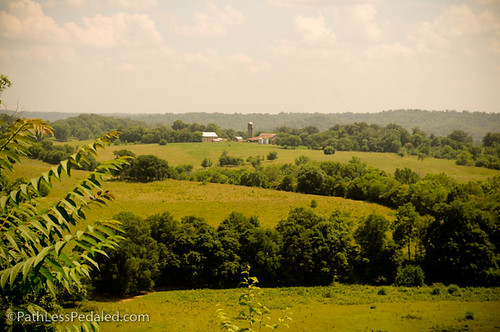
In the morning, we were up as soon as the sun was, eager to get on the road and log some miles before it got too incredibly hot. As you make your way North, the terrain changes from flat and swampy in South/Central Mississippi to grassy, rolling hills in Tennessee. We decided that we much preferred the open feeling of the grassy hills of Tennessee, even if it meant more climbing.

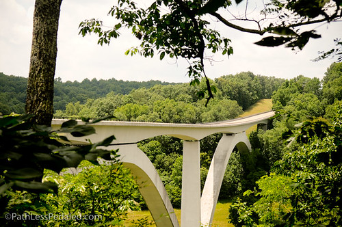
We turned off the Trace to detour to the historic area of Leipers Fork. It’s a small village that’s become very quaint in recent years, with galleries and small shops. We stopped at Puckett’s Grocery for burgers, which they are known for (with good reason), and chatted with four cyclists out on a day ride. From Leipers Fork, we headed back to the Trace and rode the last short stretch of parkway. Just a few miles from the end, you cross Highway 96 on a very tall bridge. From the roadway, you can’t see the architectural wonder of the bridge, but there’s a view point just to the north where you can look back and take in the beauty of the bridge and the valley that it crosses.
A few more rolling hills and then a wonderful downhill finish and you’re done with the Natchez Trace. Unfortunately, there’s no sign saying that you’re leaving, just an unceremonious wooden fence and a “Jct Hwy 100” sign. We snapped a photo anyway, then bid farewell to the parkway, and headed down the road to Loveless (a Nashville institution) and on to our homestay in town.
The Natchez Trace was a lovely adventure for us, and we’re certainly glad that we rode it. It offers beautiful scenery and peaceful riding, even though you can feel like you’re in a sort of green tunnel, missing out on what’s just beyond the line of the trees. It’s a popular route for cyclists and, in some ways, we enjoyed it more than the Pacific Coast (which can be extremely packed with people and traffic). Although the Natchez Trace doesn’t seem to be nearly as big a draw for tourists as we’d envisioned (we met 10-15 other touring cyclists during our week and a half on the Trace), we highly recommend the route, especially if you live anywhere near the area. So open up your atlas and figure out how to get down here!
Fantastic journal entry Laura! Thanks for sharing your experience! 🙂
Having never been there, I would venture that you may feel that more knowledge could make “riding the Natchez Trace” a desired place to be. As you point out when bicycling, you just cannot just be seeing what it is like, or if it is open when you get there. An in-depth bicycle trip guide could therefore attract those who would like to get more of an accurate perspective and options and make a plan. Many people could benefit; maybe you have opened a potential treasure chest of recreation.
You two look a lot happier than you did a couple months ago in the cold. But, now you have to beat the heat – Northward!!!!!!!!!!
….and now, after a rest period, over to the Smokies, and then on to the BRP….
OK, now I know I need to ride the Trace — maybe this fall. Email if you want to get together while you are here!
On my life list of rides to do.
I imagine the mosquitoes grow larger as the summer days grow longer. This would make a wonderful short tour for my wife and I to do. It is close enough to home to not consume all my vacation time.
Give us a shout out if your travels find you at the southern terminus of the BRP and in need of a place to rest before taking on the high peaks in the Smokies.
Thanks for sharing your journey, Jack
Fantastic account of your bike journey on the Natchez Trace Parkway. Love the pictures. I own/operate the Natchez Trace Bed and Breakfast Reservation Service. We help cyclists with their itineraries and B&B reservations. Sometimes we assist cyclists who camp some nights and stay at B&Bs on other nights. Our site has tons of pictures, information and maps about the parkway, B&Bs, area attractions and area towns. See: http://www.NatchezTraceTravel.com.
[…] and offers alternative, long and short term. Long Beach’s biking expats cycle through the historic Natchez Trace. More Americans are traveling sans motor. Zeke survives to prove the point of yesterday’s post, […]
I later ran into that father/son duo and rode with them for a bit, then found four girls going to new orleans, so I hitched with them for the duration of the journey. Along the way we ran into 3 other tourers. I guess it just depends on when and where you are for if you’ll catch anyone.
By the way, remember you have a place to crash in nyc if you decide to come this way!
Be careful, the trace has been turned into a commuter road with cell phone junkies and suv idiots that would just as soon run over you as not. Good luck you will need it. Sad but true.
Hi,
I’m planning my trip to the trace starting from Jackson. I wondered, how did you make it with your bikes from the city to the trace? Streets seem a bit iffy on google maps, and that’s not counting the airport!
Thanks for your help,
François
[…] loved reading Russ and Laura’s A Path Less Pedaled‘ post. They had a more stormy ride than we did and were camping, which made their trip a […]