
Rode Trip: Lolo Pass – Lost Lake – Hood River
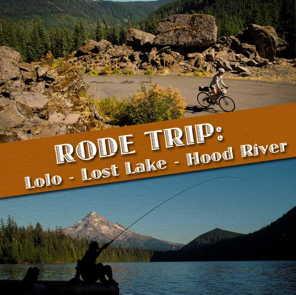
Standing on the edge of Lost Lake, with Mt Hood looming majestically in the distance, it’s easy to see why it’s the second most photographed lake in the whole state (behind only Crater Lake). As the sun set behind the forested hills and shadows crept across the water, I stood on the shore and watched as the kayakers slowly turned back toward land and Russ hooked into trout after trout. It was about as idyllic an evening as you could imagine – made all the sweeter by the challenging ride that had gotten us there.
—
Knowing the elevation profile in advance, and the fact that the temperatures were forecasted to be well into the 100s, we let public transit carry us straight to the start of the good riding – first the MAX to Gresham, then the bus to Sandy. As we loaded the bikes on the bus, the driver inquired about our impending adventure, and then cheered enthusiastically at the very idea. Here was a man who clearly relished the way his bus takes city dwellers to the foot of the mountain.
We navigated our way out of Sandy, onto Ten Eyck Road, then Marmot Road, winding alongside the Sandy River and picturesque small farms. Tall trees and wildflowers lined the road. Cows milled about in the pastures. And every viewpoint showed hills that seemed to roll out forever.
Our first glimpse of Mt Hood.
As Marmot Road ended, we turned onto Barlow Trail Road. We stopped in the small hamlet of Brightwood, where we stocked up on water and snacks at the Brightwood Store. A few miles further and we finally turned onto Lolo Pass Road, the iconic road which had lured us into this entire trip.
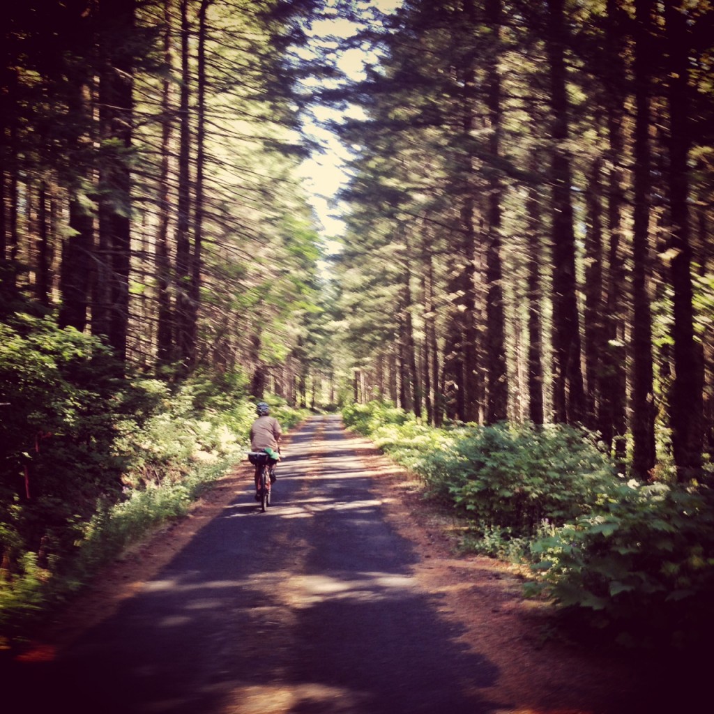
Since moving to Portland, we have heard about Lolo Pass Road. It’s a beautiful country road that lets you wind up the base of Mt Hood without the headache of the nearby highway. It provides views of the mountain and surrounding forest that you can’t see from other roads. It’s also one of the original routes across the region and once served as a final leg along the Oregon Trail. Today, it’s mostly paved and mostly ignored by motorists.
She turned out to be our constant companion.
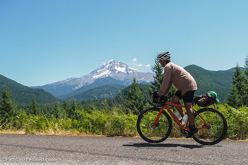
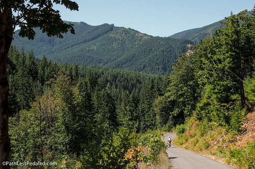
We worked our way up Lolo Pass slowly, stopping frequently to take in the spectacular views. The power lines that share the corridor meant little shade along the route, which became increasingly more brutal as the afternoon wore on and the temperature increased. But the grades were mostly gentle, so we dropped into the low gears and spun up the long climb, reminding ourselves to enjoy every moment of the long-awaited ride.
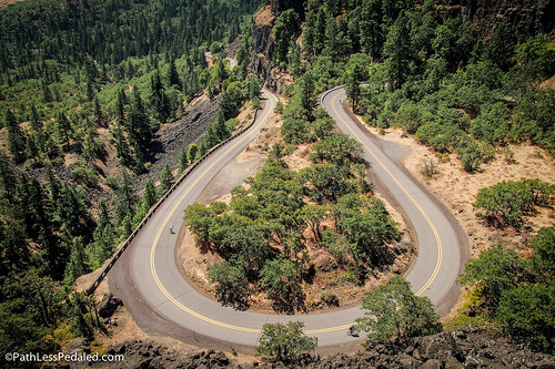
As we crested the pass level, we were met with a crossroads. Straight ahead was a very rough and rocky road, with a “not maintained for car travel” sign. The road surface to the right was more appealing, but the GPS said to go straight. A family in a minivan waved us down, concerned, when their GPS said to take yet a third option. We finally decided to go straight, and bombed down the rock garden of a road.
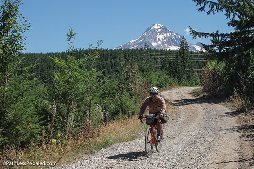
The giant chunks of rock don’t mean anything with that view, right?!
Eventually, we merged back with the main paved road, which treated us to a fast tree-lined descent, and then we hooked a left to continue on to Lost Lake Road. Russ joked that his GPS said we still had 1400 feet of elevation to climb to get to the lake, and that it must be wrong. Jinx. As we spun our way up the last few miles, the sun beat down, and car-after-car passed on their way to the lake, with rafts strapped to the roof. Slowly, we crested the last of the climb and then dropped into Lost Lake campground.
—
It has taken us a long time to finally ride Lolo Pass Road for the simple fact that we were stumped by how to ride it the way we wanted on the bikes we wanted. In our minds, this was a road that cried out for a light and fast bike, a machine that would let us simply enjoy the climb and the view – not a heavily-loaded touring bike that would get us there, but in a fashion more akin to slogging. At the same time, we wanted the freedom to stop a lot and take photos. We didn’t want to just bang it out like any ordinary day ride.
Yes, there really are that many trees.
In other words… How could we plan an overnight trip up Lolo Pass, while bringing a few necessary items and leaving the rest, and still have an adventure? How could we go “credit card touring” without the often-negative connotation of going “credit card touring”?
If you’d asked us about credit card touring when we first took off six years ago, we likely would have scoffed at the very idea. For us, at that time, the fun of traveling by bike centered around the self-sufficiency of carrying all our stuff with us wherever we went. A week’s worth of food, six gallons of water, extra wool layers, metalsmithing tools… whatever we needed to be able to ramble off into the middle of nowhere for an extended period. But strip away the stuff, and our beast-of-burden bikes weren’t “fun” on their own. As we grew weary of lugging around all the gear, we began to re-think our bike travel model. Which is how, over the past year or so, we have come to appreciate and value ride quality over utility.
In fact, part of the reason we got our Warbirds was to take them up Lolo Pass. Fast and nimble, while still stout enough to handle rough terrain and a bit of gear, we knew instantly that these bikes would fit that ride in a way that surpassed our other bikes. And our spring trip to Cascade Locks had proven our hunch correct – the Warbirds could handle a super-lightly-loaded trip without sacrificing the ride quality.
But what unlocked the whole puzzle was the discovery that Lost Lake Resort (a private entity operating along the lake, just a few miles off Lolo Pass Road) offered minimalist cabins with a bed and linens, and a store stocked with beer (and, if you remember to order in advance, fresh hot pizza).
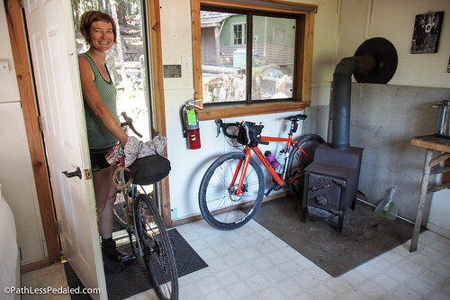
Since we didn’t need the wood stove, it provided perfect indoor bike parking.
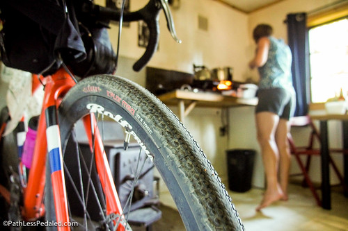
Double gas burners + pots + dishes + toaster. Pretty well set-up for a tiny cabin.
—
On the morning of Day 2, we were up early in the cool mountain air. We navigated our way our of the campground via trail, which was mostly planned but also a bit of a gamble – and which turned out to be a very bumpy shortcut to NF13. (To avoid the trail, just backtrack out of the campground and turn left.)
Before we left Portland, we were tipped off to NF13 as a better way to ride down the mountain to the NE. NF13 basically parallels Lost Lake Road, but the narrowness of NF13 makes it feel more like a bike path through the woods. Without a doubt, it was the best stretch of road of the whole trip. We passed a ranger a few times, and a couple logging trucks, but otherwise it was just us and the quiet, as we descended through giant rock flows and old growth trees.
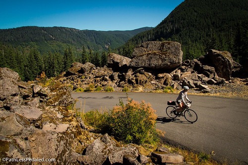
Boulders bigger than our apartment.
Quiet descent through the thick forest full of old growth trees.
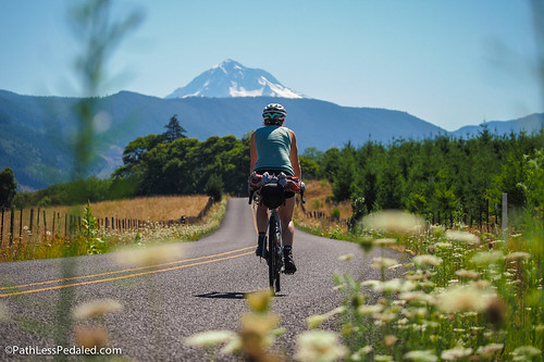
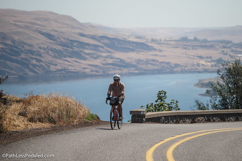
At some point, we popped out into the Hood River Valley. Mt Hood gleaming to the South, Mt Adams to the North, orchards all around. On our way into Hood River, we stopped at Tucker County Park for a fishing break. In talking with the campground staff, we learned that they now offer hiker-bike camping for just $5 per night (so does nearby Toll Bridge Park). We also learned where to find the “best street tacos in all of Hood River” – and, when I had to dust off my rusty Spanish to order, I knew it wasn’t a bluff (a little food truck by a gas station called “Nobis” for fellow taco aficionados).
—
Since we had decided to turn the ride up Lolo Pass into a whole trip, we routed a 4-day loop: up the mountain on the West, then down the North slope into Hood River for 2 nights (giving us time to ride another iconic route: the Rowena Loops), then back to Portland via the Gorge.
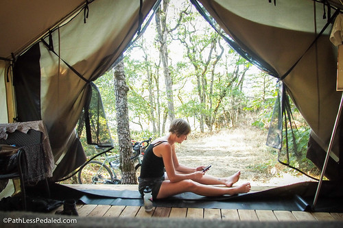
Hood River is a beautifully-appointed small tourist town, so we knew lodging wouldn’t be a problem. But after a night in a cabin in the woods, we bristled at the idea of just crashing at a motel somewhere. Small towns excel at unique lodging options, so I went hunting for something that could parallel the cabin experience. I found it in the tent cabins (also known by the terrible term “glamping”) at Vagabond Lodge.
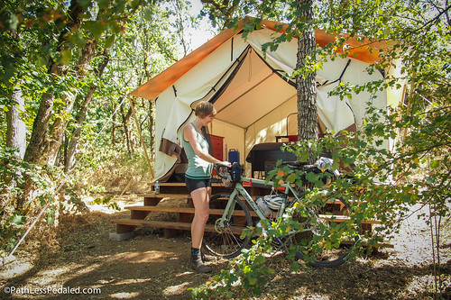
Our tent cabin, secluded, yet just a short distance to town.
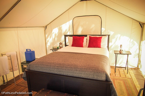
Makes you sleepy just looking at it, doesn’t it?
Set back at the edge of the property and nestled a short distance from the cliffs that drop down to the Columbia River, the tent cabins felt like some modern-day version of Hemingway going on safari. The soft-side canvas tent was pitched on a wooden plank floor, set up several feet off the ground. Beautifully furnished, it came with a vintage-styled cooler, full water jug, and LED lanterns. No electricity, no running water, a short walk to the outdoor shower and porta-loo. The only downside is the low rumble of traffic from the nearby freeway, although the crickets put up a pretty good fight for loudest white noise.
—
Our “layover” day in Hood River was meant to be a long day ride, a chance to tick off some of the iconic area rides. We decided to head out to Rowena Crest, along the Historic Columbia River Highway. From Hood River, we followed the state trail through the Mosier Twin Tunnels, then passed through the small community of Mosier, before continuing through the orchards and vineyards.
Mother Nature was out in force that morning, determined that her latest heat wave should keep us all inside by the air conditioner. By this point, we had traveled far enough to the East that we were officially on the “dry side” of the state, meaning no shade, and the little wind that kicked up was hot and dusty. Still, we were determined. We were also not alone, and the several dozen other cyclists on the road far outnumbered the cars.
We reached Rowena Crest and peered down at the twisting curves of the old road. And then we kicked off. When the road was first built 100 years ago, it conformed to the needs of the cars at that time: wide curves, gentle grades. But it feels as if it was built for cycling, because those wide curves and gentle grades let you let off the brakes, lean in, and just enjoy the ride.
They don’t build roads like this anymore. Absolutely perfect descent.
The next day, we would return to Portland via the very-familiar-to-us Historic Columbia River Highway corridor. But it didn’t escape our attention, at that moment, that we had successfully pulled together a multi-day, lightly-loaded-yet-bikepacking-esque, Lolo Pass themed trip. Our pursuit of Lolo had also enabled us to check off several other iconic NW rides. Despite the heat and the moments of getting lost, it absolutely lived up to our hopes and expectations.
After soaring down the Rowena Loops, we turned around and rode them back uphill. We backtracked our morning route, and stopped in Mosier for a taco lunch. And then, when we were safely back in Hood River, we waited out the rest of the 109-degree day with a few perfectly cold adult beverages.
Climbing back up Rowena Crest, with the mighty Columbia River in the background.
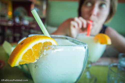
Margarita salt is an electrolyte replacer, right?!
—
Curious about the route we took? The GPS tracks of our route are below…
– Sandy to Lost Lake. Remember that we took the straight and rocky route over Lolo Pass. To avoid all that bumpiness, turn right. Both roads intersect again.
– Lost Lake to Hood River. With no signs and a confused GPS, we didn’t realize that the trail had delivered us to NF13 – so we did some extra credit and rode uphill until we found a sign that told us we had been exactly where we wanted to be. If you take the trail, just turn left.
“metalsmithing tools” hahaha!
Great write-up! That’s a wonderful route you two chose.
I think I might have passed you two on your way down the east side of Lolo. I was riding up over the pass on the paved side while you two were at the bottom of a very winding descent through the power lines.
We waved. I was solo on a mountain bike with revelate bags (if you could tell…). If it was you I saw, I remember because you were the only riders loaded for touring who I’d seen all weekend.
Anyhoo, glad you had fun on your first trip over Lolo. It’s a real beauty!
Cheers
-Joe F
Joe,
That was us. Nice to see a fellow bicyclist on the road! Did you start from Hood River? What was your route? It was our first time biking that way. So much to explore around Hood.
Russ
Definitely copying this route and will have to take a long weekend. Looks like a lot of fun and of course the scenery is great.
Nice ride!
Ah yes, GPS can get you into trouble, but thankfully, this time it didn’t. When I rode Lolo Pass Road in 2012, I heard from the ranger at the Zigzag Ranger Station that they have to “rescue” a few tractor-trailers from the road each winter. Despite the fact that the road prohibits commercial traffic/tractor-trailers (and is signed) and that the road isn’t maintained in winter, some unlucky trucker decides to drive over Lolo Pass because their GPS indicates it’s the shortest way to get back to 84 from US 26. So they’ll drive until they can’t, and since there’s no way for the truck to turn around, they have to get towed out.
And I understand that riding as light as possible is always best, but I rode Lolo Pass Road with my moderately-laden boat-anchor LHT, and didn’t find it that much of a slog. I just got in the low gear and kept spinning. So for other folks considering riding Lolo Pass, don’t be intimidated!
My friend Stephen and I mostly followed this route to Hood River from where we followed the river (old highway) mostly back to Portland. It was done in the wonderful sunshine of late September and it was a magical ride and we would like to thank you for posting it. It inspire us to do more and it was worth it. It was one of the many reason we came to Portland rather than anywhere else in the North West on our short trip from Australia.
Justin,
Awesome! Glad you guys enjoyed the route!.
Best,
Russ
Wow! I loved your account of the riding you did. So inspiring. I live in inner SE Portland and have always wanted to ride in the Gorge. Having lived on the WA side in a commune in the ’70s, I familiar with the WA side so your article got me interested in the OR side.
One question: I’ve toured carry about 40lbs and that’s too much weight for me. About how many lbs were you carrying? You said “light,” but can you please be more specific? Thanks for the great story! Jane
Hey there Jane,
On this trip, we were able to link together some creative lodging (cabin on Lost Lake, tent-cabin in Hood River) and because of this we didn’t have to carry any shelter. Both places also had food nearby so no cooking gear either. It was a treat 🙂 So our loads were probably in the 20lb range.
Russ
When I used to live in Brightwood I would ride Lolo Pass fairly often. I usually preferred to go up using FS 1828, which branches off to the east (right) near the Muddy Fork before the real climbing starts. It’s quieter, shadier, and gets far less traffic. The main road is better for bombing down though 😉
Hey There! Awesome writeup. I’m hoping to ride this same route to Lost Lake at the end of May. Do you think Lolo will be clear to ride by that time?